


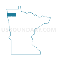
Warren W-1, Marshall County, Minnesota
About
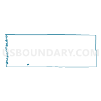
Outline

Summary
| Unique Area Identifier | 603071 |
| Name | Warren W-1 |
| County | Marshall County |
| State | Minnesota |
| Area (square miles) | 0.54 |
| Land Area (square miles) | 0.54 |
| Water Area (square miles) | 0.00 |
| % of Land Area | 100.00 |
| % of Water Area | 0.00 |
| Latitude of the Internal Point | 48.20014260 |
| Longtitude of the Internal Point | -96.77023490 |
Maps

Graphs
Select a template below for downloading or customizing gragh for Warren W-1, Marshall County, Minnesota


Neighbors
Neighoring Voting District (by Name) Neighboring Voting District on the Map
- Boxville Twp. Voting District, Marshall County, MN
- McCrea Twp. Voting District, Marshall County, MN
- Warren W-2, Marshall County, MN
- Warrenton Twp. Voting District, Marshall County, MN
Top 10 Neighboring County Subdivision (by Population) Neighboring County Subdivision on the Map
- Warren city, Marshall County, MN (1,563)
- McCrea township, Marshall County, MN (241)
- Warrenton township, Marshall County, MN (103)
- Boxville township, Marshall County, MN (39)